


Outdoor navigation meets touchscreen simplicity in Dakota 20. This rugged, palm-sized navigator combines touchscreen navigation, high-sensitivity GPS with HotFix™ satellite prediction, barometric altimeter, 3-axis electronic compass and microSD™ card slot in one affordable, power-packed punch.
Touch and Go
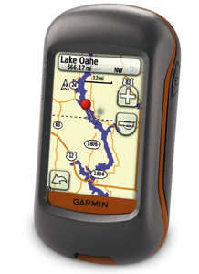
Dakota 20 makes outdoor navigation effortless with a tough, sunlight-readable, 2.6 inch color touchscreen display. The interface is easy to use, so you'll spend more time enjoying the outdoors and less time searching for information. Both durable and waterproof, Dakota 20 is built to withstand the elements: bumps, dust, dirt and water are no match for this rugged navigator.
Get Your Bearings
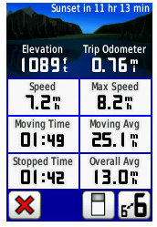
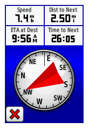
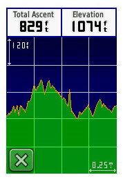
Dakota 20 has a built-in 3-axis electronic compass, which shows your heading even when you're standing still or not holding the device level. Its barometric altimeter tracks changes in pressure to pinpoint your precise altitude, and you can even use it to plot barometric pressure over time, which can help you keep an eye on changing weather conditions. And with its high-sensitivity, WAAS-enabled GPS receiver with HotFix™ satellite prediction, Dakota 20 locates your position quickly and precisely and maintains its GPS location even in heavy cover and deep canyons.
Find Fun
Get into paperless geocaching with Dakota 20 by quickly downloading up to 2,000 caches, with information such as location, terrain, difficulty, hints and description no more paper print outs and manually entered coordinates.
Explore the Terrain
Dakota 20 comes with built-in worldwide basemap, so you can navigate anywhere with ease. Adding more maps is easy with Garmin's wide array of detailed topographic, marine and road maps, available on microSD card.
Share Wirelessly
With Dakota 20 you can share your waypoints, tracks, routes and geocaches wirelessly with other compatible Dakota, Foretrex®, Oregon® and Colorado® users. Now you can send your favorite route or geocache location to a friend easily. Just touch "send" to transfer your information to similar devices.
Dakota 20: Touchscreen navigation for the great outdoors.
Garmin Dakota 20 Personal GPS


Description
Details
Physical & Performance:
- Unit dimensions, WxHxD:2.2" x 3.9" x 1.3" (5.5 x 10 x 3.3 cm)
- Display size, WxH:1.43"W x 2.15"H (3.6 x 5.5 cm); 2.6" diag (6.6 cm)
- Display resolution, WxH:160 x 240 pixels
- Display type:Transflective color TFT touchscreen
- Weight:6.75 oz (191.4 g) with batteries
- Battery:2 AA batteries (not included); NiMH or Lithium recommended
- Battery life:20 hours
- Waterproof:yes (IPX7)
- Floats:no
- High-sensitivity receiver:yes
- Interface:USB
- RoHS version available:yes
Maps & Memory:
- Basemap:yes
- Preloaded maps:no
- Ability to add maps:yes
- Built-in memory:850 MB
- Accepts data cards:microSD™ card (not included)
- Waypoints/favorites/locations:1000
- Routes:50
- Track log:10,000 points, 200 saved tracks
Features:
- Automatic routing (turn by turn routing on roads):yes (with optional mapping for detailed roads)
- Electronic compass:yes (tilt-compensated, 3-axis)
- Touchscreen:yes
- Barometric altimeter:yes
- Geocaching-friendly:yes (paperless)
- Outdoor GPS games:no
- Hunt/fish calendar:yes
- Sun and moon information:yes
- Tide tables:yes
- Area calculation:yes
- Custom POIs (ability to add additional points of interest):yes
- Unit-to-unit transfer (shares data wirelessly with similar units):yes
- Picture viewer:no
Parts Included
Dakota 20
Lanyard
USB cable
Owner's manual on disk
Quick start manual