
Get in touch with your wild side with Oregon 400t. This next-generation handheld features a rugged, touchscreen along with preloaded topographic maps, 3-D map views, a high-sensitivity receiver, barometric altimeter, electronic compass, microSD card slot, picture viewer and more. Even exchange tracks, waypoints, routes and geocaches wirelessly between similar units.
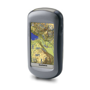
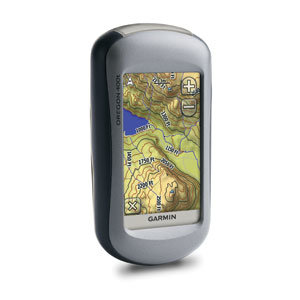
Garmin Oregon 450t Personal Handheld GPS Navigator


Description
Details
Touch and Go
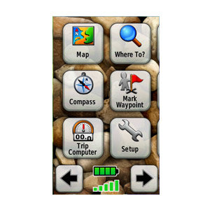
Oregon 400t leads the way with a tough, 3-inch diagonal, sunlight-readable, color, touchscreen display. Its easy-to-use interface means you'll spend more time enjoying the outdoors and less time searching for information. Both durable and waterproof, Oregon 400t is built to withstand the elements. Bumps, dust, dirt, humidity and water are no match for this rugged navigator.
Explore Backcountry in 3-D
Oregon's preloaded U.S. or European topographic maps, 3-D map view and a built-in worldwide basemap with shaded relief give you all the tools for serious climbing or hiking. Map detail includes national, state and local parks and forests, along with terrain contours, elevation information, trails, rivers, lakes and points of interest. Just in case you're wondering how steep that hill really is, Oregon's 3-D map view helps you visualize your surroundings giving you a better perspective of the elevation.
Share Wirelessly
With Oregon 400t you can share your waypoints, tracks, routes and geocaches wirelessly other compatible Oregon, Colorado and Dakota users. Now you can send your favorite hike to your friend to enjoy or the location of a cache to find. Sharing data is easy. Just touch send to transfer your information to similar units.
Find Fun
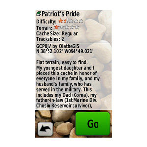
Oregon 400t supports Geocaching.com GPX files for downloading geocaches and details straight to your unit. By going paperless, you're not only helping the environment but also improving efficiency. Oregon stores and displays key information, including location, terrain, difficulty, hints and descriptions, which means no more manually entering coordinates and paper print outs! Simply upload the GPX file to your unit and start hunting for caches. Show off photos of your excursions with Oregon's picture viewer. Slim and lightweight, Oregon is the perfect companion for all your outdoor pursuits.
Keep Your Fix
With its high-sensitivity, WAAS-enabled GPS receiver and HotFix satellite prediction, Oregon 400t locates your position quickly and precisely and maintains its GPS location even in heavy cover and deep canyons. The advantage is clear whether you're in deep woods or just near tall buildings and trees, you can count on Oregon to help you find your way when you need it the most.
Get Your Bearings
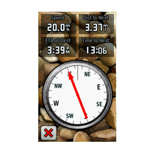
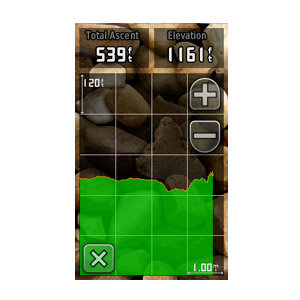
Oregon 400t has a built-in electronic compass that provides bearing information even while you're standing still, and its barometric altimeter tracks changes in pressure to pinpoint your precise altitude. You can even use the altimeter to plot barometric pressure over time, which can help you keep an eye on changing weather conditions.
Add Maps
Conveniently plug in optional preloaded microSD cards for all your outdoor activities on land or water (see the Maps tab for compatible maps). Just insert a MapSource® card with detailed street maps, and Oregon provides turn-by-turn directions to your destination. Access whitewater runs or explore equestrian trails by purchasing US Trailmaps for Whitewater and Equestrian. Or, you can add regional, detailed trail and lake information with our TOPO U.S. 24K maps. With BlueChart® g2, you'll get everything you need for a great day on the water including depth contours, navaids and harbors. The card slot is located inside the waterproof battery compartment, so you don't have to worry about getting it wet.
Get Connected
You've been busy exploring and now you want to store and analyze your activities. With a simple connection to your computer and to the Internet, you can get a detailed analysis of your activities and send tracks to your outdoor device using Garmin Connect. This one-stop site offers an activity table and allows you to view your activities on a map using Google Earth. Explore other routes uploaded by millions of Garmin Connect users and share your experiences on Twitter® and Facebook®. Getting started is easy, so get out there, explore, and share.
Oregon 400t: Touch the great outdoors.
Parts Included
Oregon 400t
Carabiner clip
USB cable
Owner's manual
Quick start guide